![](/images/other/stat-length.png)
![Trail Walking Les Fourgs - La stratégique - belvédère de la roche sarrazine - Photo](https://media.geolcdn.com/t/1900/400/ext.pjpeg?maxdim=2&url=https%3A%2F%2Fstatic1.geolcdn.com%2Fsiteimages%2Fupload%2Ffiles%2F1553511878bg_sport_marche.png)
La stratégique - belvédère de la roche sarrazine
cyrghe
User
![Length](/images/other/stat-length.png)
Length
12.2 km
![Max alt](https://static1.geolcdn.com/siteimages/upload/files/1508320355ic_sort_altitude_max_24dp.png)
Max alt
1202 m
![Uphill gradient](https://static1.geolcdn.com/siteimages/upload/files/1508320355ic_sort_den_pos_24dp.png)
Uphill gradient
209 m
![Km-Effort](/images/other/stat-length.png)
Km-Effort
15 km
![Min alt](https://static1.geolcdn.com/siteimages/upload/files/1508320355ic_sort_altitude_min_24dp.png)
Min alt
1077 m
![Downhill gradient](https://static1.geolcdn.com/siteimages/upload/files/1508320355ic_sort_den_neg_24dp.png)
Downhill gradient
206 m
![Boucle](https://static1.geolcdn.com/siteimages/upload/files/16400158638029165_repeat_loop_refresh_sync_direction_icon.png)
Boucle
No
Creation date :
2019-07-21 09:33:52.0
Updated on :
2019-07-21 11:33:57.046
![Walking](https://static1.geolcdn.com/sitytour/trail-icons/101.png)
1h45
Difficulty : Easy
![Scan this QR Code to open this trail in the SityTrail application](https://capi.geolives.com/qq0zvz2zws4bq2lad0pu/sitytour/trails/2146400/qr.png?size=200)
FREE GPS app for hiking
About
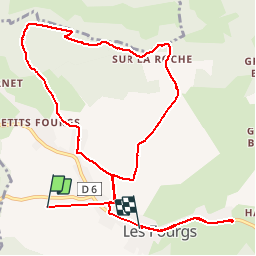
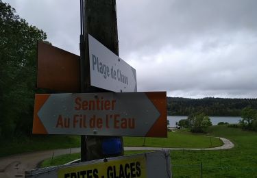
Trail Walking of 12.2 km to be discovered at Bourgogne-Franche-Comté, Doubs, Les Fourgs. This trail is proposed by cyrghe.
Description
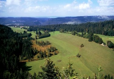
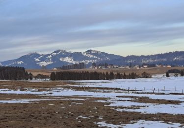
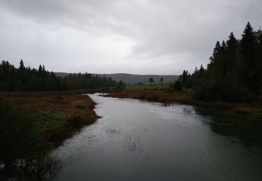
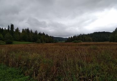
Belle petite balade, très sympathique, très facile, alternance de clairières, sous-bois et paysages du haut-Doubs. Très beau point de vue depuis le Belvédère avec table d’orientation.
Positioning
Country:
France
Region :
Bourgogne-Franche-Comté
Department/Province :
Doubs
Municipality :
Les Fourgs
Location:
Unknown
Start:(Dec)
Start:(UTM)
300950 ; 5190245 (32T) N.
Comments
Trails nearby
![Trail Walking Les Fourgs - Le Stratégique - Doubs - Photo](https://media.geolcdn.com/t/375/260/ext.jpg?maxdim=2&url=https%3A%2F%2Fservices.sitytrail.com%2FGeolivesWS%2FDownloadMedia.ashx%3FTrailID%3D108935%26Media%3D2626_1.jpg)
![Walking Walking](https://static1.geolcdn.com/sitytour/trail-icons/101.png)
Le Stratégique - Doubs
Walking
Medium
(1)
Les Fourgs,
Bourgogne-Franche-Comté,
Doubs,
France
![](/images/other/stat-length.png)
8.3 km | 10.6 km-effort
2h 45min
![](https://static1.geolcdn.com/siteimages/upload/files/16400158638029165_repeat_loop_refresh_sync_direction_icon.png)
Yes
![Trail Walking Les Fourgs - 2024-01-31_00h34m12_le-belvedere-de-la-roche-sarrasine_randonnee-2285212 - Photo](https://media.geolcdn.com/t/375/260/ext.jpg?maxdim=2&url=https%3A%2F%2Fstatic1.geolcdn.com%2Fsiteimages%2Fupload%2Ffiles%2F1553511878bg_sport_marche.png)
![Walking Walking](https://static1.geolcdn.com/sitytour/trail-icons/101.png)
2024-01-31_00h34m12_le-belvedere-de-la-roche-sarrasine_randonnee-2285212
Walking
Difficult
(1)
Les Fourgs,
Bourgogne-Franche-Comté,
Doubs,
France
![](/images/other/stat-length.png)
12.4 km | 17 km-effort
3h 51min
![](https://static1.geolcdn.com/siteimages/upload/files/16400158638029165_repeat_loop_refresh_sync_direction_icon.png)
Yes
![Trail Cross-country skiing Les Fourgs - Piste du Voirnon - Photo](https://media.geolcdn.com/t/375/260/ext.jpg?maxdim=2&url=https%3A%2F%2Fmedia.geolcdn.com%2Ff%2F4d46f533-833e-4cab-9d13-d16310de5eba.jpg)
![Cross-country skiing Cross-country skiing](https://static1.geolcdn.com/sitytour/trail-icons/502.png)
Piste du Voirnon
Cross-country skiing
Easy
Les Fourgs,
Bourgogne-Franche-Comté,
Doubs,
France
![](/images/other/stat-length.png)
11.8 km | 15.2 km-effort
3h 39min
![](https://static1.geolcdn.com/siteimages/upload/files/16400158638029165_repeat_loop_refresh_sync_direction_icon.png)
Yes
![Trail On foot Les Fourgs - Le Sentier des Bornes - Photo](https://media.geolcdn.com/t/375/260/ext.jpg?maxdim=2&url=https%3A%2F%2Fmedia.geolcdn.com%2Ff%2F4777e0b5-35d9-430b-b18b-01a7bbd1a8dc.jpeg)
![On foot On foot](https://static1.geolcdn.com/sitytour/trail-icons/100.png)
Le Sentier des Bornes
On foot
Easy
Les Fourgs,
Bourgogne-Franche-Comté,
Doubs,
France
![](/images/other/stat-length.png)
6.4 km | 8 km-effort
1h 48min
![](https://static1.geolcdn.com/siteimages/upload/files/16400158638029165_repeat_loop_refresh_sync_direction_icon.png)
No
![Trail Cross-country skiing Les Hôpitaux-Vieux - Les Essarts - Photo](https://media.geolcdn.com/t/375/260/ext.jpg?maxdim=2&url=https%3A%2F%2Fmedia.geolcdn.com%2Ff%2F133bf42f-84e7-4637-b480-7581e8a779ca.jpg)
![Cross-country skiing Cross-country skiing](https://static1.geolcdn.com/sitytour/trail-icons/502.png)
Les Essarts
Cross-country skiing
Easy
Les Hôpitaux-Vieux,
Bourgogne-Franche-Comté,
Doubs,
France
![](/images/other/stat-length.png)
6.5 km | 8.1 km-effort
2h 3min
![](https://static1.geolcdn.com/siteimages/upload/files/16400158638029165_repeat_loop_refresh_sync_direction_icon.png)
Yes
![Trail Walking Montperreux - Chaon Saint Point - Lac - Photo](https://media.geolcdn.com/t/375/260/ext.jpg?maxdim=2&url=https%3A%2F%2Fmedia.geolcdn.com%2Ff%2F1cb44616-4442-4252-833e-fb8b82bf1bbb.jpg)
![Walking Walking](https://static1.geolcdn.com/sitytour/trail-icons/101.png)
Chaon Saint Point - Lac
Walking
Easy
(1)
Montperreux,
Bourgogne-Franche-Comté,
Doubs,
France
![](/images/other/stat-length.png)
15.1 km | 19.4 km-effort
3h 5min
![](https://static1.geolcdn.com/siteimages/upload/files/16400158638029165_repeat_loop_refresh_sync_direction_icon.png)
Yes
![Trail Walking Montperreux - Sentier de la découverte - Chaon Malbuisson - Photo](https://media.geolcdn.com/t/375/260/ext.jpg?maxdim=2&url=https%3A%2F%2Fmedia.geolcdn.com%2Ff%2F9dad01dd-973e-4ef4-b8da-7f7478c28fff.jpg)
![Walking Walking](https://static1.geolcdn.com/sitytour/trail-icons/101.png)
Sentier de la découverte - Chaon Malbuisson
Walking
Easy
Montperreux,
Bourgogne-Franche-Comté,
Doubs,
France
![](/images/other/stat-length.png)
9.8 km | 12.3 km-effort
2h 12min
![](https://static1.geolcdn.com/siteimages/upload/files/16400158638029165_repeat_loop_refresh_sync_direction_icon.png)
Yes
![Trail Walking Montperreux - La Gouille - Photo](https://media.geolcdn.com/t/375/260/ext.jpg?maxdim=2&url=https%3A%2F%2Fmedia.geolcdn.com%2Ff%2F85cd76c8-b938-42d3-aec6-148fb2329c9a.jpg)
![Walking Walking](https://static1.geolcdn.com/sitytour/trail-icons/101.png)
La Gouille
Walking
Easy
Montperreux,
Bourgogne-Franche-Comté,
Doubs,
France
![](/images/other/stat-length.png)
8 km | 10.1 km-effort
1h 53min
![](https://static1.geolcdn.com/siteimages/upload/files/16400158638029165_repeat_loop_refresh_sync_direction_icon.png)
Yes
![Trail Walking Montperreux - La source bleue - Photo](https://media.geolcdn.com/t/375/260/ext.jpg?maxdim=2&url=https%3A%2F%2Fmedia.geolcdn.com%2Ff%2F8f4113b6-be86-421b-922f-6c8f51836eb0.jpg)
![Walking Walking](https://static1.geolcdn.com/sitytour/trail-icons/101.png)
La source bleue
Walking
Easy
Montperreux,
Bourgogne-Franche-Comté,
Doubs,
France
![](/images/other/stat-length.png)
9.8 km | 13.4 km-effort
2h 13min
![](https://static1.geolcdn.com/siteimages/upload/files/16400158638029165_repeat_loop_refresh_sync_direction_icon.png)
Yes